MELBOURNE: Next winter could be cold across the northern US as odds increase that a La Nina will replace the fading El Nino in the Pacific Ocean.
A La Nina watch was issued Thursday as the warming across the equatorial Pacific’s surface began to fade and cold water started building in its depths, the US Climate Prediction Center said. There is a 60 percent chance the La Nina could occur from July to September and a 70 percent chance there will be one in the winter.
The Australian Bureau of Meteorology issued a watch on Tuesday.
“These are definitely not a guarantee but they are high enough that we decided to go ahead and issue the watch so folks are aware,” said Michelle L’Heureux, a forecaster with the climate centre in College Park, Maryland. “The fact is, we are already starting to see some real strong changes in the ocean.”
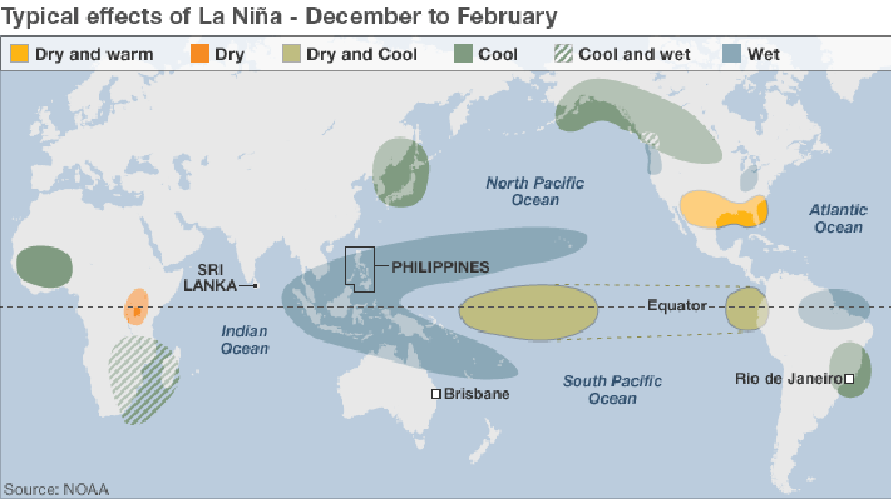
La Ninas occur when the surface of the Pacific cools, bringing on an atmospheric reaction that can upset global weather patterns and move commodity and energy markets. In addition to helping cause colder winters across the northern US, the phenomenon also means heavier monsoons in India as well as more rain across parts of Indonesia, Australia and Brazil.
The Indian Meteorological Department predicts this year’s rainy season will be above average for the first time since 2013. The opposite would probably happen across the southern US, as La Ninas can make that region drier and warmer.
La Ninas could also mean less wind shear across the Atlantic, which may allow more hurricanes to form.
L’Heureux said the layer of warm water that marked this year’s El Nino has begun to fall apart.
“It is really becoming quite thin and degrading rapidly,” she said. “The subsurface temperatures are really cooling off.”
The latest El Nino contributed to a record warm winter in the 48 contiguous US states, a drought across many Pacific islands and fires in Indonesia.
While the El Nino that is fading was one of the strongest ever, that doesn’t mean there will be a long wait for the Pacific to cool, L’Heureux said.
“The thing with strong El Ninos is if they transition, they transition pretty quickly,” L’Heureux said. “If a La Nina were to form, it would be pretty quick.”
(La Niña is a coupled ocean-atmosphere phenomenon that is the counterpart of El Niño as part of the broader El Niño–Southern Oscillation climate pattern. The name La Niña originates from Spanish, meaning "the girl", analogous to El Niño meaning "the boy". During a period of La Niña, the sea surface temperature across the equatorial Eastern Central Pacific Ocean will be lower than normal by 3–5 °C. In the United States, an appearance of La Niña happens for at least five months of La Niña conditions. It has extensive effects on the weather in North America, even affecting the Atlantic Hurricane Season. A La Niña often, though not always, follows an El Niño. Picture: BBC News)